Devizes Wireless Station 1913 - 1929
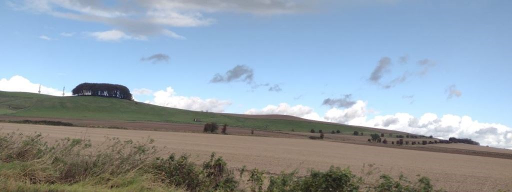
The south western slopes of Morgan’s Hill in the parish of Bishops Cannings, Wiltshire probably don’t hold much interest to the hundreds of commuters passing by daily on the A361 north east of Devizes and its link to the A4 south east of Calne. The hill looks similar to many others in the Downs, perhaps a little higher than some. Walkers and cyclists venturing on the many paths crossing the hill may give a passing thought to radio masts on the summit, but few are aware of the purpose of numerous concrete blocks and a dilapidated building on the south western side. Could what happened here have a direct link to the protection of Avebury and its prehistoric archaeology? Dave Sabin outlines what is known about the site and discusses the possible link to Avebury.
Devizes Wireless Station was a short-lived site but played a remarkable part in wireless development in the early 20th century from just pre-WWI to the late 1920s. Initially the first receiving station constructed by Marconi as part of the Imperial Wireless Chain, then used by the military in WWI for direction finding and intelligence (MI1e) and finally maritime communications in the post-war period with demolition in 1929.
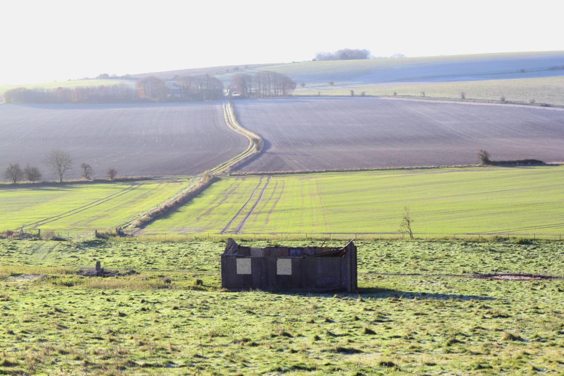
Dilapidated wireless station building
The Imperial Wireless Chain was proposed by the Marconi Company in 1910 as a number of wireless telegraphy transmitting and receiving stations that would link up the British Empire. It was considered to be cheaper and less vulnerable than the existing submarine cable network. A contract between the government and Marconi Wireless Company was eventually signed early in 1912 with an approval in August 1913 to construct six wireless stations linking England to Australia.
Morgan's Hill, in the parish of Bishops Cannings near Devizes in Wiltshire, was selected as the site for the receiving station at the British end of the chain. The location was chosen probably partly due to it being Crown Land with military sites nearby, but also its close proximity to the underground telegraph cable link between Porthcurno, where the submarine telegraph cables come onshore, and London. This link passed just 2 miles to the north of the wireless site following the line of the A4 and could be used to transfer messages received by the station to London by wire, it was buried underground in 1906. The elevated hillside and the electrically 'quiet' surroundings were probably also factors considered when choosing the location. At this time receivers had very poor rejection of electrical noise generated by early vehicle magneto-based ignition systems, electric motors, generators, etc.
The associated transmitter was due to be built on Crown Land at Leafield in the Oxfordshire Cotswolds, around 4 miles north west of Witney, to prevent severe interference to the receiving equipment. In fact the high power transmitter was located at almost exactly 90 degrees to the line of the aerial at Devizes on the north eastern side and this was probably deliberate as the aerial would be less responsive to the low frequency vertical signals at this angle. The aerial would have some signal gain towards the south east, the direction that signals transmitted from the next station in the chain at Abu Zabal in Egypt would arrive from. At the outbreak of WWI (August 1914) both sites seem to have had masts installed, with some masts also installed at Abu Zabal.
Soon after the outbreak of WWI, the Royal Engineers moved onto the site to adapt it for military use. Information regarding how the site was used during the war is scant. However, GCHQ archives indicate Devizes as the main intercept site for military intelligence MI 1(e). There is also some evidence for Radio Direction Finding (RDF or DF) experimentation at the site possibly early on during WWI, this may have involved the main aerial being used as a transmission source with portable DF stations taking bearings to it through the use of a number of smaller directional aerials. Later in the war the site was also used for training in signals intelligence.
Ordnance Survey mapping from 1922 shows the location of six 300 foot masts in a line running approximately north west to south east, the most north westerly mast being within the north eastern part of the North Wilts Golf Club course and the most south easterly being approximately 450m south west of Shepherd's Shore on the A361. A seventh unmapped mast was located at the north western end within the golf course and two smaller masts or termination points were located at the ends of the aerial to allow tensioning, these are also unmapped features.
Plans of the site held by the National Archives probably relate to the original Marconi construction in 1913 and these show only six 300 foot masts so it is likely that the seventh may have been an addition at the centre of the aerial system possibly later in the WWI period. The plans also show that Marconi intended to construct buildings associated with the actual receiver off the south eastern end of the aerial, immediately south east of the A361 near to Shepherd's Shore, press articles also indicate that workers cottages were to be built within the vicinity; however, there is no evidence that the station or cottages were built at this location.
The remains of the station and associated earthworks are located at the centre point of the aerial and this was probably chosen by the army soon after the outbreak of war, it also reflects a change of purpose for the site so that instead of using a long wire aerial, or Marconi Inverted L aerial, to obtain some gain for receiving signals from Egypt, the site could potentially become more flexible. The central location is also quite remote and more secure being well away from the A361, although it did require the construction of a dedicated road. Photographs of the station from the 1920s, when it was under the control of the GPO, show corrugated iron clad huts likely to have been constructed by the army during WWI.
The total length of the aerial at the 300 foot above surface level would have been approximately 2030m (2220 yards) with possibly some additional length to the lower tensioning/termination masts at each end. The large square area of fencing around each mast includes the mast stay blocks. The initial 1913 construction did not include fencing but it was added as as a security measure after suffragettes entered the Leafield site (associated transmitter location) in 1914.
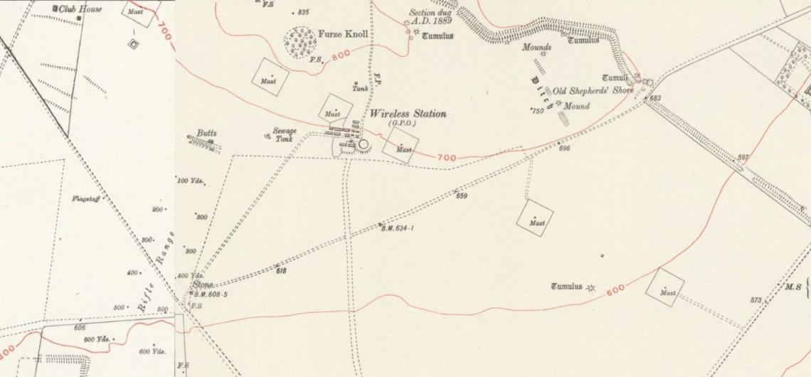
Map of the wireless station and six of the seven 300 foot masts from the early 1920s © Crown copyright. OS license no. 100043739
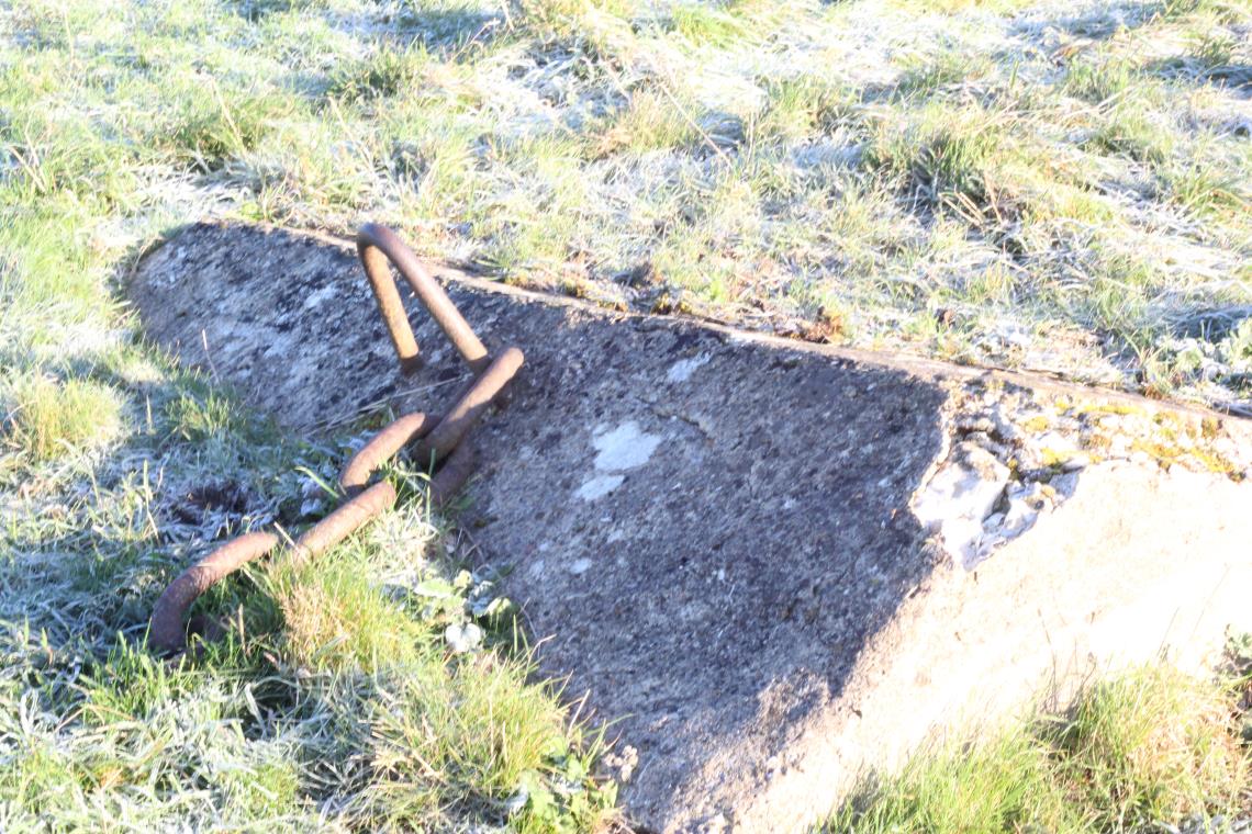
Still visible on site are large blocks of concrete where the base of each tubular mast was fixed to a circle of threaded studs.
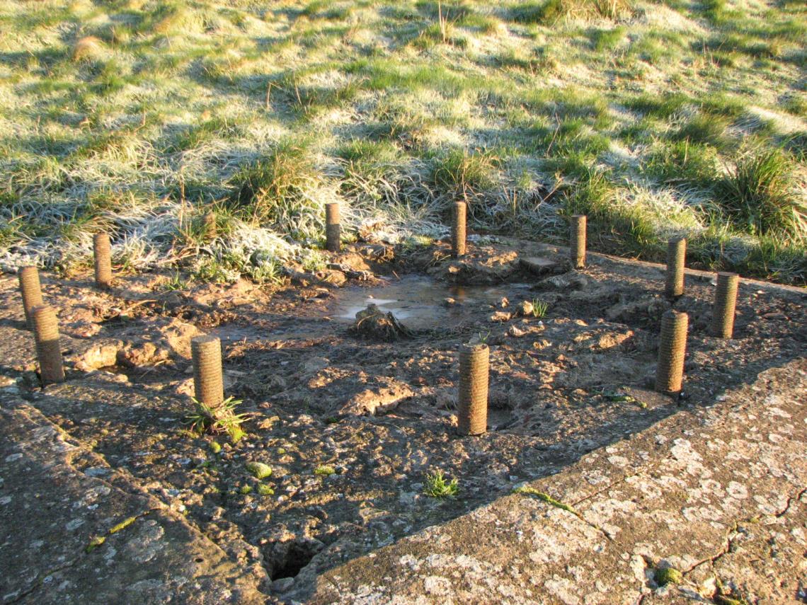
Concrete base with ring of studs (mast no. 4 from north west end)
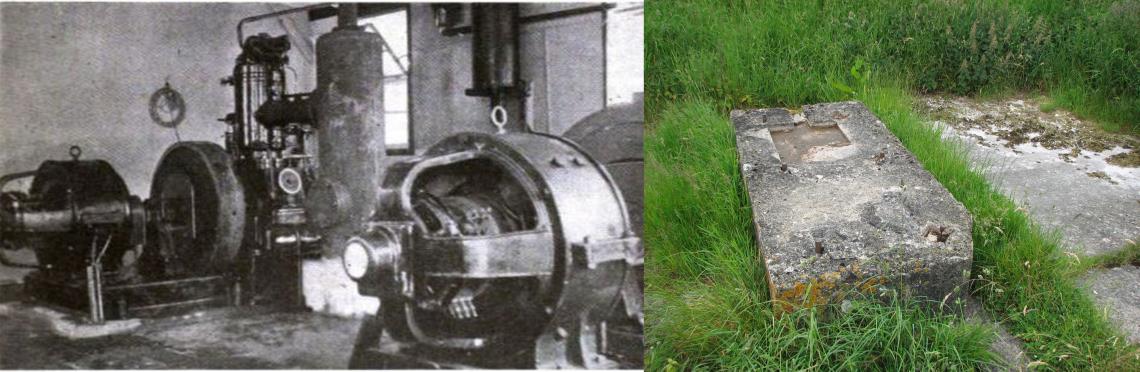
Around each mast base there are other concrete blocks in four lines running away from the bases and separated by an angle of 90 degrees to form a cross shape; these were fixings for a series of supporting cables at different heights up the masts, the face of each block would have contained a steel link for attaching a cable and these appear to change angle slightly to account for the different angle each set of cables makes with the anchor block as height increases, effectively ensuring the tension in each cable is perpendicular to the face of each block at the fixing point.
Concrete stay block with chain (mast no. 3 from north west end)
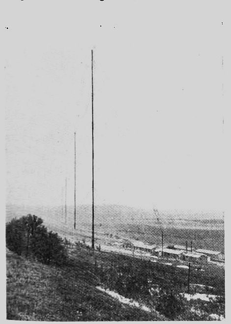
View of Devizes Wireless Station taken looking south east prior to 1924 (masts 4 - 7 visible)
The above photograph was taken looking south east along the line of four of the masts with the wireless station buildings visible to the right, three masts would have been behind the photographer. The image was probably taken between 1920 and 1923 prior to an article about the site's later use as a maritime communication facility (published in Experimental Wireless in February 1924). At this time the station aerial only used the first two masts visible in the photograph and it is unlikely that any aerial system remained between the other masts. Marconi opened the first long wave transmitting site in Britain near Caernarfon in 1913, around the time of the construction of the Devizes and Leafield sites, and a photograph of what is likely to be a very similar tubular mast section can be seen at historypoints.org. The Leafield site is likely to have had identical masts, a short film can be found on https://www.britishpathe.com/asset/168972/ showing the masts in 1921 when the site was opened as part of the revival of the Imperial Wireless Chain post-WWI, the Devizes Wireless station was, however, no longer part of the scheme. (Note: a new receiving site was paired with the Leafield transmitter and this was located at Bodicote Grounds Farm, now devoured by the south eastern part of Banbury. The new site received wireless signals from the 100kW arc transmitter located at Abu Zabal in Egypt. To minimise interference from Leafield the alignment of the Banbury aerial was towards Abu Zabal but also at a right angle to the direction of signals from the transmitter, which in this case was towards the south west).
Post WWI, the site was taken over by the General Post Office (GPO) and in August 1920 a maritime communication service, callsign GKU, began with both transmitting and receiving equipment in operation. A wavelength of 2100m (142.75kHz) was used to generate C.W. (continuous wave) signals that were keyed for morse communication. The C.W, transmitter used valves and produced an output power of 6kW, the aerial used only two of the seven 300 ft tubular masts.
Technical problems with the receiver at Devizes resulted in the purchase by the GPO of a site at Highbridge near Burnham-on-Sea in 1924 for the construction of a separate receiving station where Radio Officers could key the transmitter at Devizes by landline links. However, further technical issues at Devizes gave rise to the construction of a new transmitter site at Portishead near Bristol in 1926 (the receiving site remained at Highbridge), which became well known as "Portishead Radio" , the operation ceased in 2000.
The Devizes site became an experimental station for short wave transmission, the higher frequencies allowing global communication with much lower power. There is reference to a third short-wave transmitter being constructed at Portishead in the late 1960s and this was to replace the original transmitter, considered rather outdated, that was originally installed at Devizes in 1927 and presumably moved to Portishead around 1929 when Devizes closed and was dismantled. Incredibly, this had been in use for over 40 years. Further information about Devizes, including a photo of the huts, is available at https://portisheadradio.co.uk/devizes-radio
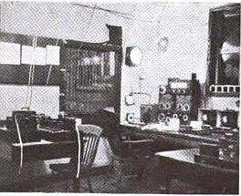 Maritime station operating room prior to 1924
It is clear that Portishead Radio, at one time the world's largest maritime wireless station, had its origin at Devizes and this is acknowledged by a wealth of information available on the site in the book "Portishead Radio" by Larry Bennett who was a Station Officer there at the time of the site's closure. The book provides a detailed background on Devizes, the receiving site at Highbridge and the transmitter site at Portishead, details below.
Marconi and Avebury
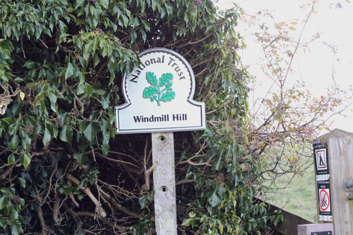
It is well documented that Alexander Keiller purchased parts of Avebury, including Windmill Hill and the West Kennet Avenue, between 1924 and 1939. The purchase of Windmill Hill was to prevent the Marconi Company from constructing a large wireless station associated with the revived Imperial Wireless Chain, as reported in August 1923.
The Wiltshire Archaeological Society did not object to the scheme as Marconi had given assurances that monuments would be protected, although some members did not agree and opposed the scheme. Concerns were raised by many other eminent archaeologists and the plan was eventually dropped. It is unlikely that Windmill Hill was actually under any threat and Keiller continued to purchase land at Avebury long after the Marconi threat.
The company's interest in Avebury may well relate to its close proximity to the Devizes site which had been partly built by Marconi as the first receiver station of the Imperial Wireless Chain in 1913. Avebury would have close proximity to the main artery of the telegraph network running along the A4, it would have been electrically quiet and the Marconi Company were familiar with the area as although Devizes was run by the GPO, much of the equipment was supplied by Marconi which may have assisted in short-wave tests at the site. At this time Marconi’s experiments with short-wave radio communication were demonstrating cheaper and more reliable long distance communications compared to long wave.
The Empire Wireless Committee produced recommendations in 1924 stating that any wireless stations should be in the hands of the state, meaning the General Post Office. However, in March 1923 Prime Minister Bonner Law announced that private companies would be allowed to develop and run wireless stations. By April 1923 it was reported that the Marconi Company had identified a site on the Marlborough Downs (Avebury) and a second alternative site in the Midlands. The idea of constructing a second long wave site close to the long wave station at Devizes, then under the control of the GPO, seems unrealistic due to problems of interference unless the plan was to close the Devizes maritime communication site down and move staff to Avebury. In 1925 it is known that a number of staff transferred to "Portishead Radio" (i.e. Highbridge and Portishead) to continue their work in maritime communications.
In August 1923 The Times printed an article about the affair which included a reference to "the erection of a large number of masts, 800 feet high" etc. Could Avebury have been a candidate for the high power low frequency transmitter installation located near Rugby? The site known as Rugby Radio Station, close to Hilmorton in Warwickshire, was chosen in 1923 around the time of the interest in Avebury. It required masts just over 800 feet in height and covered a large area of around 1600 acres (the potential acquisition at Avebury was reported to be around 10,000 acres). Rugby was, therefore, very likely to have been the alternative site as indicated by the April 1923 article. It seems that the government did not proceed with the use of a private company and followed the recommendations of the Empire Wireless Committee with Rugby constructed and operated by the GPO. It was initially part of the revived Imperial Wireless Chain but later took on a number of different roles.
However, this was a period of rapid technological change in radio communications, and a press report from 1923 implies Marconi were looking to develop multiple stations at the one site for communicating with more distant parts of the empire using short-waves. This would account for the large area of land Marconi were interested in around Avebury. In 1924 the Beam Wireless Service opened from Bodmin with other sites in operation soon after (1924 photo of Bodmin Beam Wireless Station). The short wave equipment at these sites utilised large curtain arrays which were directional aerials that helped to focus or beam radio waves towards parts of the world where radio communication was required. It is possible that the plans for Avebury would have seen the construction of the Rugby long-wave station and all of the short-wave Beam Wireless Stations at the one site. If constructed this would have been an extremely large site and although visually intrusive and potentially destructive to the archaeological resource in places, large areas may well have been protected from the ravages of modern cultivation.
The plans for Avebury may never be fully known but it seems likely that the initial pre-WWI construction of the Devizes Wireless site by Marconi, the installation of Marconi equipment at Devizes, certainly after the war if not during, and the close proximity of the two sites (just 4 miles apart) gave the company local knowledge of suitable land with similar characteristics to Morgan’s Hill, but with less steep slopes and more shelter, a location more suitable for the construction of buildings and large aerial arrays.
Future work and further thoughts
The story of this site continues to develop and it is hoped that in future the remains can be recorded in detail and that this hillside in the western part of the North Wessex Downs can have some recognition as a former location for the development of radio communication technology and intelligence gathering.
In researching this site, and as a geophysicist encountering numerous other sites from all periods, I often find myself considering what is archaeologically significant and why certain periods are attractive while others are barely considered to be part of our heritage or have archaeological value. In the mid-20th century, industrial archaeology started to be recognised as an important area of research and this gathered pace as early industrial sites disappeared through the latter part of the century. In the last few decades there has also been growing interest in the archaeology of wartime military sites. These areas of archaeological research recognise and react to the loss of living human memory from those periods along with the degradation, demolition and erosion of the physical remains.
Perhaps it is now time that we recognise the archaeology of the technology that has brought us to where we now are in the 21st century, in particular pioneering sites not specifically related to the military where there continues to be significant interest. The story of Devizes Wireless Station both pre and post WWI is wrapped up in geopolitics and rapid technological innovation, and it is a story largely untold and lost in less then a century from its closure.
Finally, the press article below reflects on the juxtaposition of the high-tech engineering of the wireless station with that of a number of ancient archaeological features in its vicinity. It does 'loose the plot' slightly towards the end!
After the felling of 3 masts........
"In the early part of September, three crashed to the ground, sacrificed on the Altar of Progress. It seems particularly fitting that this site should have been chosen for the scene of destruction; the offspring of the most modern branch of Engineering laid low amidst the ruins of the most ancient! Local antiquaries will tell you, if you are interested, of the great feats of those Neolithic Engineers, who, at Avebury ages before men learnt to use iron implements, built those huge circles of stone within whose confines sun-worshippers conducted their religious rites. They will speak with enthusiastic voice of the mighty deeds of the civil engineers of ancient times, who, restrain the predatory encroachments of hostile Lords, excavated the great dyke that skirts the boundary of the Radio Station site. These deep ruts crossing the line of the masts, mark the road made by Roman military engineers, and many an invading chariot has passed this way in great days of old.
The trails of the engineer have left their mark unobliterated even by the passing of Time! Many other tails will be told, but if you pass down from the hill into the villages below the story you will hear most often concerns that sad passing of those 300-foot masts.
Picture the scene as the anxious moment arrived to put the scheme to the test! Holding a sledgehammer aloft, the executioner stands above the pin. A word of command and the heavy tool swings quickly down. The pin flies out, the stays slacken and fall in towards the mast. For a moment the ‘stately and air-heaving tower’ remains erect, and then a great shout goes up. “She’s falling! She’s toppling over!” Slowly at first, but with ever-increasing speed, the structure heels about the base.
And now, the story of the passing of the masts is told. If, on that mid-September night when the last mast fell, you had chanced to pass by the great stones in the quiet village of Avebury, you would have seen – as the moon rose – small dark figures flitting about the ground, and heard a whispering sound rising and falling with gentle cadence. You and I, cold matter-of-fact engineers, would have dismissed the matter with some crude remark about shadows and leaves about. But the Poet, with wiser discernment, will tell you that these were no shadows caused by the rustling leaves, but elves and goblins jauntily capering around the great hoary stones, chanting joyously their triumphant song.”
Trees and steel will bend and bow,
Wood and clay will wash away,
Build it up with stone so strong:
Huzza! ’twill last for ages long".
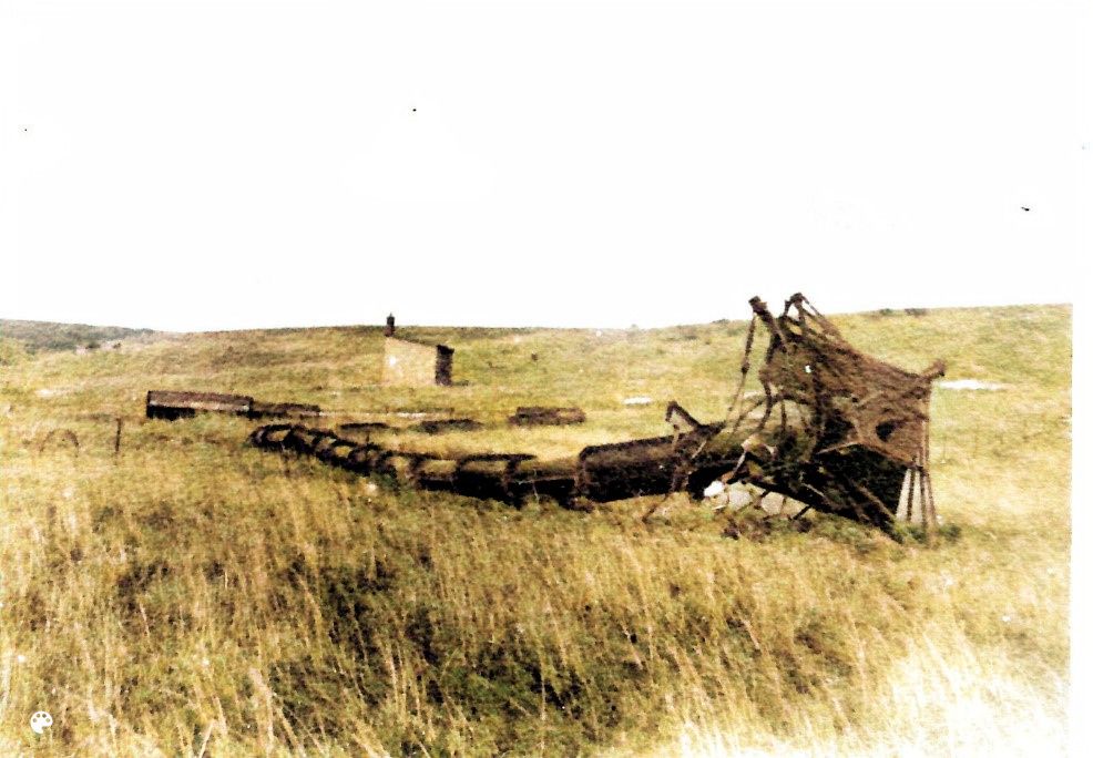
Image reproduced with kind permission from Larry Bennett
Acknowledgments and References
The information gathered for this article has numerous sources many of which are not specifically related to the wireless station and are available online.
However, I acknowledge the research carried out by Terry Crawford in particular who I thank for information offered through direct communication and set out in his excellent book: Wiltshire and the Great War, Training the Empire's Soldiers (DPF 1999, ISBN 0-9535100-0-x).
Many thanks to Associate Professor Cassie Newland for direct communication regarding the location of the wireless station and her interesting article: Mr Hopgood's Shed, a paper in Beyond the Dead Horizon: Studies in Modern Conflict Archaeology published by Oxbow Books in 2012.
Thanks to Martyn Barber for direct communication regarding his reference to Marconi and Avebury within Stonehenge World Heritage Site Landscape Project. Stonehenge Aerodrome and the Stonehenge Landscape. English Heritage Research Report Series no. 07-2014
The work of Larry Bennett is acknowledged as a vital source of information for the post-WWI phase of Devizes Wireless Station and this has been obtained by direct communication, through the Portishead Radio website (see below) and through his book: Portishead Radio, a Friendly Voice on Many a Dark Night (New Generation Publishing 2020, ISBN 978-1-80031-896-0). We have a small number of signed copies that are available from us for £10 +p&p, please email info@archaeological-surveys.co.uk
Websites
100 Years of the UK's Long-Range Maritime Radio Service, Sea Breezes Publications Ltd. https://seabreezes.co.im/100-years-of-the-uks-long-range-maritime-radio-service/ [accessed September 2023]
Defending Our Skies, GCHQ. How Signals Intelligence helped combat air raids in World War I. https://www.gchq.gov.uk/information/defending-our-skies [accessed May 2023]
Devizes Radio. https://portisheadradio.co.uk/devizes-radio [accessed October 2023]
Portishead Radio GKA. https://portisheadradio.co.uk/home [accessed October 2023]
Post Office Radio Station, Devizes by J.H.Reyner, Experimental Wireless Vol.1 No.5 February 1924. https://worldradiohistory.com/UK/Experimental-Wireless/20s/Experimental%20Wireless-1924-02.pdf [accessed May 2023]