Wiltshire Archaeology Conference
Kerry Donaldson presented the results of recent survey work on the Highworth Circles and David Sabin produced a poster display of recent research into early wireless sites in Wiltshire. See below for further details on both.
Highworth Circles presentation
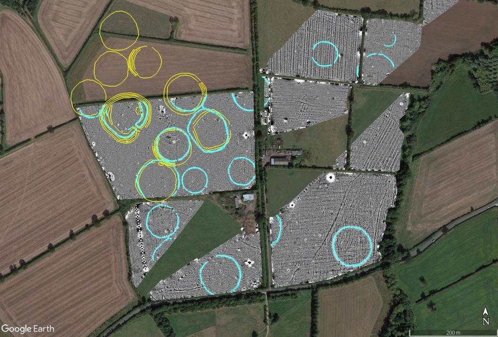
Kerry Donaldson, Archaeological Surveys Director, recently presented the results of magnetometry near Highworth at the Wiltshire Archaeology Conference in Devizes. The survey was required ahead of a new pipeline development by Thames Water and the results revealed 11 previously unknown Highworth Circles forming a group of 20 with 9 previously known examples. Other groups of circles exist in locations around Highworth and the new discoveries bring the total number of known circles to around 60.
 Greyscale plot of magnetometry data showing Highworth Circles overlying Google Earth aerial imagery
Aerial photographs, extant circles and a small number of excavations demonstrate clearly that they are formed by an inner ditch and outer bank, the diameters range from approximately 50m to 100m. The magnetometry appears to respond mainly to the ditch-fill which has produced a positive anomaly, there may be a weak negative response to the outer bank. A small number of excavations have produced early medieval pottery, mainly Minety Ware, and our geophysical results show circles clearly cutting (and therefore later than) Iron Age and Roman features. Ridge and furrow cultivation appears to cross some circles or be cut by others, so combined with the pottery finds a 13th or 14th century date seems likely. However, there are no historical records that can be confidently associated with the circles and their morphology combined with the large number of known examples is highly unusual, if not unique, in this period. It also appears that the circles are contemporaneous as they do not cut one another and some may be linked or conjoined.
The naming of these features as Highworth Circles highlights their uniqueness within the country - there are no clear parallels and as such do they represent something that only occurred within this part of England? It is highly likely that they formed animal enclosures; however, although a range of animal bones have been located, excavation works have been too limited to provide conclusive evidence on animal types, and the remains of dead animals may not be representative of the live animals that were presumably held in the circles. Highworth lies a short distance to the south of the Thames and Roman Ermin Street also passes a few miles to the west, so it's possible this area is located at a bottleneck for droving animals from the west and Wales towards the east and south east. The Thames can be crossed easily to the north west of the area but becomes a significant barrier to the north east. Could the circles be used for temporary containment of animals moving through the area? Could the large number of circles represent different ownership of stock? Could the area have been a significant market zone where ownership of animals changed hands?
Early Wireless Sites in Wiltshire
David Sabin, Archaeological Surveys Director, produced a poster display for the Wiltshire Archaeology Conference mainly focusing on the archaeology of modern technology in the form of early wireless sites. The posters were commented on by a number of people attending the conference and highlight the importance of relatively recent sites that have previously had little recognition and can demonstrate a direct path to today's technology.
Last year David did a short presentation on the nationally important site of Devizes Wireless Station located just a few miles away from the conference in the parish of nearby Bishops Cannings.
The site was chosen by the government in 1913 as the first receiving station of the Imperial Wireless Chain (IWC), a concept promoted by Marconi whereby a number of transmitter and receiver sites could be linked to allow communication right across the British Empire. Although largely constructed in 1913, the site never functioned within the IWC due to the outbreak of WWI. Subsequently, the military take over the site and use it for direction finding and interception of wireless messages as well as training - the site becomes the home of military intelligence in wireless telegraphy (MI 1e). Post-war the GPO use the site for a highly successful maritime communication service that rapidly outgrew the location resulting in an initial move of the receiving section to Highbridge at Burnham followed by the construction of a new transmitter site at Portishead in 1926. This became the internationally renown Portishead Radio closing in 2000 but tracing its origin to Devizes which was demolished in 1929.
We have a small number of books on "Portishead Radio", written by Larry Bennett, that detail the maritime operation at Devizes in the opening chapter, please email info@archaeological-surveys.co.uk if you are interested in a signed copy (£10 +p&p). Further information on the site is available at Devizes Wireless Station (archaeological-surveys.co.uk).
More recent research into Wroughton Wireless Receiving Station was undertaken to try and identify the exact location of the site. In 1927, the station was the receiver part of the world's first transatlantic wireless telephone service, the powerful transmitter being located at Rugby with Wroughton receiving signals originating from the eastern side of the USA and relaying these on to London by underground cables.
This highly secret site was nothing more than a wooden shed full of high-tech equipment and as such it's exact location was unknown. However, a request to Wroughton History Society resulted in the discovery in their own archive of clearly labelled photographs of the site, the location recorded as Rectory Farm which was demolished in 1937 ahead of the construction of Wroughton airfield. The farm had been located very close to the where the runways intersect in the centre of the airfield. Geophysical survey in the vicinity of the former site of Rectory Farm revealed only magnetic debris associated with its demolition.
Wroughton is thought to have used an extremely long aerial system known as a Beverage, notes from the Rugby Radio archive refer to this as being 7 miles in length. The aerial would have been mounted quite close to the ground, probably on wooden telegraph poles, and it would have been aligned towards the transmitter in the USA so it could have extended just to the south of Wootton Bassett, although its exact route is currently unknown. An experimental receiver site at Chedzoy in Somerset was likely to have been almost identical and was operational a few years before Wroughton, although was not eventually part of the telephone service. Wroughton itself was soon replaced by a receiver located in a more favourable location in Scotland.
We have a small number of books "The Marconi Beam Wireless Stations of Somerset", written by Larry Bennett, that detail the Chedzoy receiving site that was probably an identical precursor to Wroughton, please email info@archaeological-surveys.co.uk if you are interested in a signed copy (£14 +p&p). Further information on the is available at Wroughton Wireless Receiving Station (archaeological-surveys.co.uk)