Lugbury Long Barrow
Download a PDF copy of the full report (13Mb)
Archaeological Surveys Ltd was commissioned by Wiltshire Council Archaeology Service to undertake a geophysical survey of Lugbury Long Barrow near Nettleton, Wiltshire. The survey was requested due to the continued impact of ploughing on the barrow which is designated a Scheduled Monument (SM 12290). The work has been carried out under the Monument Management Scheme funded by English Heritage.
Summary
Survey techniques included magnetometry, resistivity and ground penetrating radar. Topographic survey using survey grade GPS and LiDAR analysis was used in support of the geophysical data. Magnetometry survey was carried out across the barrow and within the field in which the barrow resides, whilst resistivity and ground penetrating radar were targeted on the barrow mound within the scheduled area.
Magnetometry clearly revealed flanking quarry ditches/pits to the north and south of the barrow. The magnetic anomalies suggest a series of interconnecting pits forming elongated ditches with occasional discontinuities giving the appearance of more discrete pit-like features.
The data from all of the geophysical techniques revealed variable response across the barrow mound with little coherence. No clear evidence for internal structure was obtained and this may support the historical evidence for complete excavation in the mid 19th century. However, it is possible the presence of jumbled limestone at very shallow depth has effectively obscured deeper features.
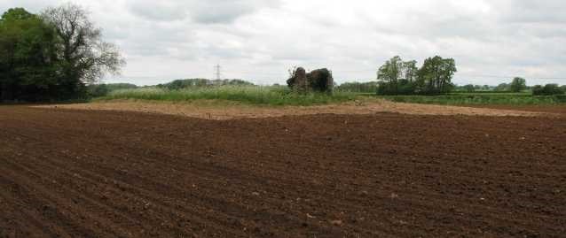
Geophysical data combined with topographic survey data and LiDAR data have clearly demonstrated the encroachment of ploughing in recent years and support field observations over the last decade. The current plough limit clearly encroaches onto the barrow 'structure' as visible in the magnetometry and resistivity data.
Magnetometry also revealed a number of other features of agricultural and natural origin and possible areas of quarrying. No evidence for a round barrow to the east of the long barrow was visible in the data. The round barrow had been recorded by John Aubrey as being ploughed away before 1630. A linear anomaly to the east of the long barrow appears to relate to a former track of medieval date. A linear anomaly in the north eastern part of the field may indicate a former route to the Fosse Way that may also be visible in LiDAR data.
Archaeological background
Lugbury is an example of a Neolithic long barrow, or megalithic chambered tomb, of the Cotswold Severn region. There are at least 220 of this type of chambered tomb within south east Wales, Gloucestershire, Somerset, Oxfordshire, Berkshire and Wiltshire (Corcoran, 1969, Darvill, 2004). These monuments are believed to have been constructed and used between 4000 and 3000BC; however, recent radiocarbon dating from five barrows across the region have identified that within four of them construction began around 3800BC and that burial ended around 3625BC (Bayliss et al, 2007). These barrows were, therefore, only used for a few generations although many of them have several phases of construction and use.
The barrow measures today approximately 50m by 15m and is 0.5m high. At the eastern end, three upright orthostats are visible, these have been known as a cromlech since antiquity. John Aubrey recorded the barrow with its orthostats during the 17th century and also noted that “near to this stone was a little round barrow, before it was ploughed away since AD 1630” (Jackson, 1862).
There have been two previous recorded investigations of the barrow, both taking place within the 19th century. In 1821 Sir Richard Colt Hoare conducted an excavation along a 150ft (45m) length of the barrow. He found that charcoal had been mixed in with the natural ground surface at around 6ft deep, and that the floor and sides of the barrow had been constructed with a layer of loose stones. A wall was uncovered by the cromlech, with a second wall oriented north-south discovered approximately 60ft (18.3m) to the west. Between these two walls, some 30ft (9.14m) to the west of the cromlech, was discovered the inhumation of a young adult male, lying in a stone lined cist some 2ft (0.6m) deep, over which a “rude arch” had been constructed and orientated east-west (although Colt Hoare seems to have queried that it may have been north-south (Crawford, 1925), with the knees drawn up level with the hips and a sharpened piece of flint lay close to his head. Colt Hoare's original manuscript shows that the dimensions of the mound were 219ft by 78ft (66.75m by 23.77m).
Colt Hoare believed that the primary burial lay at the eastern end under the cromlech but he did not want to disturb the stones for fear of them falling. In 1854 and 1855, landowner George Poulett Scrope, excavated around these stones, finding that they were buried upwards of 4ft (1.22m) below the natural ground surface. No human burials were located in the vicinity, only some fragments of Roman pottery, a foot or two from the surface, and a few fragments of boar bones, teeth and tusks and flint flakes (Thurnham, 1857).
The 1854 excavation was necessitated when ploughing revealed a stone cist on the south side, near the centre of the barrow, containing several skeletons. The subsequent investigations by Scrope, revealed a total of four stone chambers or cists on the southern side, containing seven, zero, nine and ten skeletons respectively. There was evidence of some distinction between age and gender to the relative cists they were placed in. Thurnham (1857) notes that, “the whole barrow has latterly been excavated by Mr. Scrope, but without discovering any further interments, nor anything worthy of note except two or three more flint-flakes of irregular form. The bulk of the stones having been carted away, the barrow is now consequently much reduced in elevation”.
It was reported by Thurnham (1868) that the southern ditch was visible as a depression in the field. The ditches have not been subject to recording or excavation as far as is known.
References
Baliss, A., Wysocki, M., Whittle, A., Meadows, J., van der Plicht, J., Bronk Ramsay, C., 2007. 'The times of their lives: building histories for prehistory.' Research News, No 6. English Heritage, pp 4-7.
Corcoran, J.X.W.P., 1969. 'The Cotswold-Severn Group, 1. Distribution, Morphology and Artifacts', in Powell, T.G., Corcoran, J.X.W.P., Lynch, F., and Scott, J.G., Megalithic enquiries in the west of Britain. Liverpool: Liverpool University Press, pp 13-72.
Crawford, O.G.S., 1925. Long Barrows of the Cotswolds. Gloucester. Bellows.
Darvill, T. 2004. Long Barrows of the Cotswolds. Stroud. Tempus.
English Heritage, 2001. West Kennet Long Barrow, Wiltshire, Report on a Geophysical Survey. [online] available from http://www.eng-h.gov.uk/reports/west_kennet/
Jackson, J. E., 1862. Wiltshire: the topographical collections of John Aubrey.
Thurnham, J., 1857. 'On a cromlech-tumulus called Lugbury near Littleton Drew'. Wiltshire Archaeological and Natural History Magazine, Volume 3, pp 164-177.
Thurnham, J., 1868. 'On Ancient British Barrows especially those of the Wiltshire and adjoining counties. Part 1 - Long Barrows.' Archaeologia 42, pp 161-244.